
By way of introduction I should warn you that I’m one of those guys who looks at a map and is fascinated by the thin blue and gray lines that wander off into nowhere in particular. I can’t help but wonder what the country these roads traverse is like.
Travel has always been a part of my life. My first major adventure on the road was in the early 1970s when I planned a road trip to Nova Scotia from southwest Missouri in a 1966 Volvo 1800S with two kids (just over one and almost four), mostly by writing for information. The basis of my research was a listing of state and provincial tourism agencies I found in the travel section of the local newspaper. I wrote letters to each state and province we anticipated visiting and it took several weeks for all of the information to arrive. Long distance telephoning was quite expensive and virtually everything was done by mail. I took the maps and planned routes that looked logical. The process took a lot of time but the effort was worthwhile as we thoroughly enjoyed the experience.
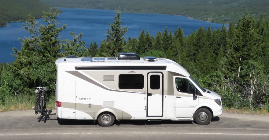
Planning a major adventure on the road today has evolved significantly over the last several decades. While the Internet has revolutionized how we plan travel, there is still an important place for some of the traditional resources. My wife and I have talked about a trip to Alaska for many years, but two years ago I started planning what an actual road trip to Alaska might look like. The conveyance is to be our 2013 Leisure Travel Vans Unity U24IB.
The resources at our disposal are almost limitless. This article is based on the process I went through in planning our own Alaska adventure that is planned for July 2015 and I will share some of the resources I found most helpful. One more word of caution: it is important to recognize that individual travel styles vary significantly. Some prefer group travel and others prefer experiencing travel adventure alone. There is no right or wrong unless you find yourself doing a trip with someone else’s travel style. Personally, my wife and I lean toward solo road adventures and the flexibility (and, yes, sometimes challenges) that the style presents so my planning is from that perspective.
Resources I find most helpful:
- Milepost (no trip to Alaska should be without it)
- Internet (almost limitless resources)
- Guide Books (quite a range, written from differing perspectives)
- AAA/CAA (helpful in obtaining maps and basic guide books, as well as providing emergency roadside assistance)
- Your file of articles on Alaska (yes, you should have one!)
- Information from others who have taken similar trips (notes go in your file)
- Computer map program (mapping capability when you don’t have Internet access)
- GPS
Milepost
No effort to plan a trip to Alaska is complete without a current copy of Milepost, billed as “Legendary Alaska trip planner and Alaska travel guide to the highways, roads, ferries, lodgings, recreation, sightseeing attractions and services along the Alaska Highway to and within Alaska, including Alberta, British Columbia, Northwest Territories and the Yukon.” That’s quite a mouthful, but in truth it is that and more. The “more” is their website – what a resource. Here’s a brief list of what you’ll find:
In the printed Milepost:
- Mile-by-mile highway logs of 30 major routes and side trips
- Over 15,000 miles of guidance and over 100 maps
- Information on ferries, accommodations, sightseeing, wildlife viewing, and road conditions
- Buy a new Milepost printed copy and get free access to the Digital Edition for your tablet or notebook
On the Milepost website:
- Fuel prices for Alaska, British Columbia, and Alberta to help you estimate the fuel cost of your adventure
- When to go during the summer travel season is always a question and you will find information about weather and facilities
- Answers to most questions will be found under Driving the Alaska Highway
- Current updates on attractions and road conditions and links to innumerable other resources
Internet
The resources in this category are virtually limitless, but all searches should start with the official state of Alaska vacation and travel information website at www.travelalaska.com. Here you’ll find photos and videos, things to do, places to stay, tips on both travel to and within Alaska, and numerous planning helps.
Find a road or point of interest that looks interesting, just do a search on Google (or your favorite search engine) and you will find all kinds of interesting information, often posted by independent travelers who share their experiences.
Guide Books
There are numerous guide books on Alaska. One of my favorites is Lonely Planet’s “Alaska.” The style is casual, frank, and a bit irreverent, but it cuts through the normal fluff you find in similar guides and gives you a perspective on what you might enjoy and what you might not.
AAA/CAA
Members get free maps and guide books which can be helpful, but the roadside assistance that is part of “RV Premier” with 200 miles of free towing and assistance offer peace of mind when you are traveling not only far from home but, often, far from anywhere. Now all you need is a cell signal so you can call them.
Your File
You need to somehow keep track of small resources you come across that pertain to destinations you might like to visit. In this case, the file would be labeled Alaska. Tangent to this would be a bookmark file for Alaska on your computer. Keep articles you find in your paper file and bookmark websites you find helpful for later reference on your computer.
Information from Others
Listening to the tales of Alaska travel of friends and others you meet can be invaluable, especially if you share interests and perspectives. Their information can give you a feel for what to expect and may give you a reality check on any number of questions you might have. An example is our meeting, quite by chance, of another couple who own a Unity almost identical to ours. We met in the parking lot of a restaurant we were both about to go to for lunch. Over lunch together, we found that they had driven the Alcan Highway dozens of times and had a wealth of experience which they later shared with us in detail, including seven pages of hand-written notes on a legal size pad. Their notes are an invaluable resource.
Computer Map Program
Yes, there are numerous free mapping services available online but a map program on your laptop like Microsoft Streets and Trips (which was discontinued in 2014) gives the flexibility of route planning when you have no Internet access.
GPS
I don’t use GPS when planning, but when I’m on the road it is quite helpful. For instance, I can force the driving route to the route I’ve planned and let the GPS keep us on track. If you are looking for an address in an area you are unfamiliar with the GPS is very helpful. If you travel with a destination in mind for the end of the day, a GPS will give you an ETA based on real world conditions that can be most helpful in timing stops along the way. Not long ago our GPS helped us realize that staying on Hwy 1 north of San Francisco would place our target destination in Arcata near midnight and our hosts were looking for us for supper. The GPS then found a route through the mountains from Hwy 1 back to Hwy 101 that proved to be spectacular and we were in Arcata in plenty of time.
My Process
Let me give a brief overview of how I integrated these resources in planning our upcoming trip to Alaska.
As we started a serious planning process I found articles in my paper file about RV tour companies taking groups to Alaska. I looked carefully at their itineraries to see where they went and what they did, making notes of things that appeared to be of interest. A friend in Victoria, British Columbia, sent me an article on ten places to see in northern British Columbia and the Yukon and I read it carefully. I reviewed the notes from my new friend who has driven the Alcan so many times. I browsed my Milepost guide and visited milepost.com, making notes of places I wanted to be sure to include. I looked at the state of Alaska website and did several searches to learn more about some points of interest I had found. I stopped by AAA and got their tour guides for Alaska and Canada and nice maps for both.
Armed with this information and a lengthy list of points of interest, I entered the RV tour itineraries and the ten places from my friend’s article into Microsoft Streets and Trips. Using the “optimize stops” button I turned all of these random points of interest into one sequenced tour.
I copied the sequenced points of interest into Microsoft Word and made one vast itinerary which I started cutting into daily segments based on what I had found to see and do. Some days the itinerary called for little or no travel because there was a lot to see and do. Denali National Park, for instance, has several days allocated. In a few cases, the itinerary has travel days of a couple hundred miles.
The itinerary for each day identifies what there is to see and do and where it is. If we find that we are fascinated by a location, we simply look for a place to park for the night and slip the itinerary back a day since we travel without reservations. In cases where reservations are essential (perhaps a ferry that is seasonally busy), we know how to pace ourselves just by looking at the itinerary. The GPS can be helpful when a ferry is the next stop as it can give you the ETA for the ferry dock.
This may sound quite structured, but actually it is quite loose. The itinerary is thought of as a guide, not a master, and simply helps us focus on what we found that we thought would be of interest. Sometimes we find things that aren’t in any of the literature and, conversely, find things we thought would be interesting but aren’t.
Our Alaska Adventure
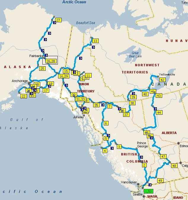
The map with this article includes everything I found rolled into one grand tour. The total mileage according to Streets and Trips is 9,932 miles from Bellingham, WA and back. Since we developed the initial plan, we signed up to volunteer for three weeks with NOMADS at Birchwood Camp about 20 miles north of Anchorage so we will adjust our real world travel accordingly.
We plan to leave for our Alaska adventure on July 1 with all of our resources onboard. Obviously, we don’t have time in July and August to drive it all. A friend of mine who has driven to Alaska many times says that the first trip will only set us up to crave another!
Our new plan is to follow the itinerary to Anchorage and use weekends while we are at Birchwood Camp to explore the Kenai Peninsula. Before we leave Birchwood Camp on July 30, we will make an assessment of what we would most like to see during the month we plan to take to get home and choose the parts of our prepared itinerary that fascinate us most.
I will report on the outcome of this planning effort in September after we return home. A special part of that report will be how we packed our Unity IB with four tool boxes, a 7′ ladder, two bicycles, and my wife’s cello … and, yes, two spare tires … all stashed inside and out of the way!
Safe travels!
Comments