Just when you think you’ve seen the best Newfoundland has to offer, you discover the Kittiwake Coast.
It’s Shangri La, a beautiful land filled with trees, hills and water. It’s a land that still retains some customs and vocabulary of ages past, yet lacks very little in the way of modernization.
The Kittiwake Coast comprises a long stretch of coast north of Gander. The variety of scenery and topography found here is unmatched anywhere else in Newfoundland. Its deeply indented coast is home to a myriad of harbours and fishing villages whose ‘old world’ charm will coax you to stay a little longer. The absence of easy access to the mainland helped keep many of the island communities unique. Causeways now connect several of the scattered islands, allowing access to a countryside that resembles the lake country of Ontario. This coast also has an unusual claim to fame. According to the Flat Earth Society, Brimestone Head on Fogo Island, is one of the four corners of the earth.
The Kittiwake Coast takes its name from the kittiwake, a sea bird with a distinctive, shrieking call. Like theearly fishermen, they too, are long distance travelers, and it is not unknown for them to cross the ocean from Europe to the Kittiwake Coast.
One very popular way of approaching the Kittiwake Coast is to take the Road to the Isles, Route 340, which exits the TransCanada Highway at Notre Dame Junction. The combination of historical significance, beauty, and friendly people is drawing large numbers of visitors to the Kittiwake Coast. Once you are in the area, you will find that you want to slow down, stay a while, and explore. The Visitor Information booth at the Junction will help you find small hotels, motels, and ‘bed and breakfast’ accommodations to serve your needs, as well as providing you with other up-to-date information about the area.
Within a few miles you reach Lewisporte. Those who savour seafood will want to be in town in August during the ‘Mussel Bed Soiree’ festival. Piles of mussels, plates of lobster, and other tasty bits from the sea, should leave you feeling stuffed, and happy to be there. You will also be entertained with a wide variety of fine music.
Lewisporte opens into the vast Notre Dame Bay that was first visited by English sailors dating back to the 17th century. Today’s enterprising voyageurs can climb aboard a boat and take a tour to explore the inlets, and the quiet channels between the islands. For more activity, squeeze into a kayak and scoot across the tranquil waters of the bay. Kayaking is a popular way of exploring the bays and channels between the islands, and some even venture out to intercept a passing iceberg. Imagine the possibilities. What a perfect opportunity to glide quietly nearer the creatures of the sea! And, think how big a humpback whale will look if it surfaces nearby!
Many years ago a man named Lewis used this harbour to ship lumber from his inland sawmills. In time, the port developed as a fishing and ship building centre. Over at the Train Park you can see the remnants of the railway that once crossed Newfoundland. On display is one of the great snowplows that kept the lines open in the winter. Although the trains won’t take you anywhere, you can catch a ferry here that will take you on a long trip into a great fjord to Goose Bay on the Labrador coast. From there a rough road reaches Churchill Falls, and connects to developed roads that head southward through the Province of Quebec to the St. Lawrence River.
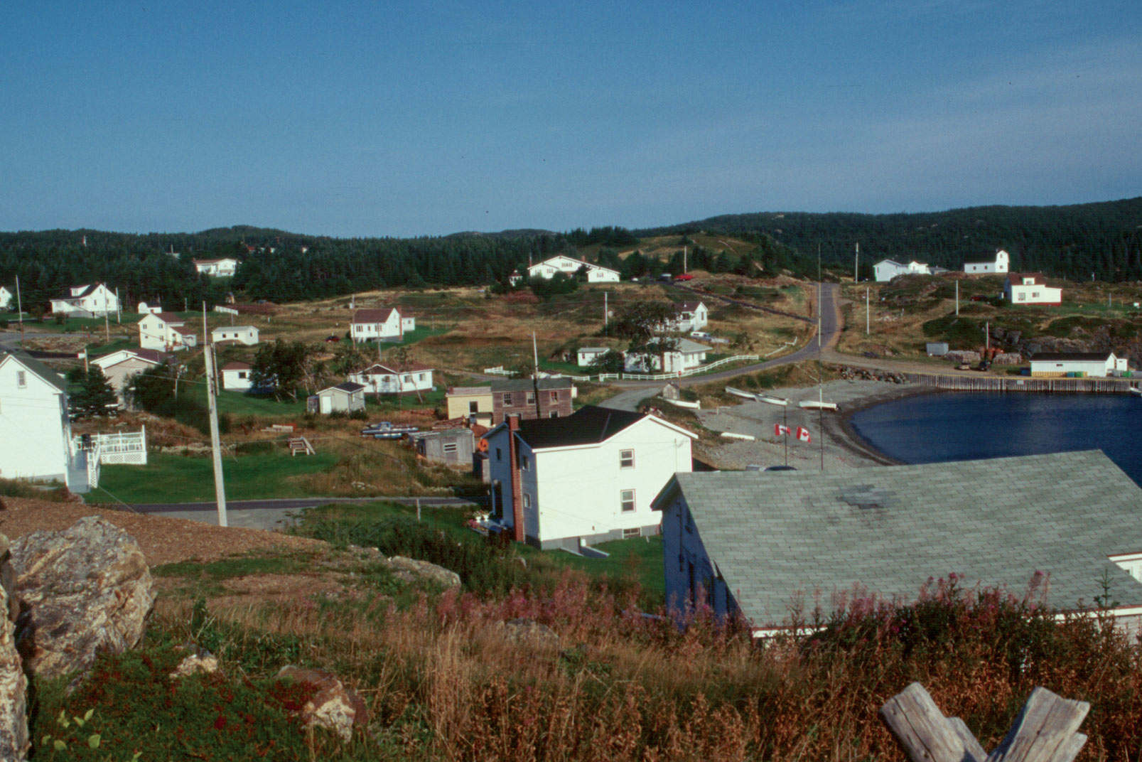
As you head north along Route 340 you are never far from the sea. You wind along the coast, and over rocky hills cloaked in maple and birch forests. Ponds and streams attempt to interrupt your progress. Everywhere there is excellent scenery, and there is water…everywhere. The sea, and the fish, brought the original visitors to these shores. Eventually, they began to build homes and develop trades. It was, and is, a rugged coast, and the people developed ways to beat the odds, and survive the harsh environment. Wherever there is a sheltered harbour, you will find their small wooden homes, and communities. Small fishing boats bob on the white-capped waves, or edge restlessly at their moorings, eager to be away to the sea.
Piled near the homes and docks are the tools of the fishermen. Expect to see piles of lobster and crab traps, along with a variety of tackle and gear. Some of the small towns have built museums to display artifacts of the past. There are many innovative tools on display, built of necessity. It wasn’t possible to run down to the mall to pick up whatever tool they needed. Some of the museums are combined with craft shops where you will find on display a wide variety of beautifully crafted objects ranging from home made quilts, to dolls.
Many of the towns were at one time thriving communities. Much of the commercial activity has been lost from the now, peaceful towns, where people go about their daily activities without the frantic hustle and bustle associated with big cities. People are exceptionally friendly, and don’t mind taking time from what they are doing to visit with you, and answer your questions. Some of their words are strange, even unknown, to outsiders. A tickle? Newfoundlanders even have their own dictionary, ‘The Dictionary of Newfoundland English’ to help you understand them. For instance, if invited to have a meal of ‘blind mush, and burgoo’, do you readily stay, or do you mention your previous engagement? Are you subject to curwibbles? The meanings of these, and many other delightfully sounding words can be found in their dictionary.
At Boyd’s Cove you will find the Beothuk Interpretation Centre. The Beothuk people were among the earliest to live in Newfoundland. While most were nomads, Boyd’s Cove is one location that had a permanent population. The Interpretation Centre illustrates their history and artifacts. It was usual for the Beothuk tribes to head inland for the winter. Many lived along the shores of Red Indian Lake, southwest of Grand Falls. As the weather warmed they moved down the Exploits River. The Exploits valley was a fertile valley, and a great resource for them. They were able to find food and shelter along the way. By the time summer arrived, they had canoed out to the outer islands where they could find fish, and birds and lots of eggs. Yet, with all of this, they lost the competition for resources to the strangers who had come to their land. And they became extinct! If you pass near Grand Falls, visit the Mary March Regional Museum, which covers human settlement in the area back 5500 years or so.
Eventually, as you head north, you reach the Twillingate area, leapfrogging the sea on the series of causeways joining some of the islands. I had not heard of Twillingate, nor would I have visited the region, if not for a chance occurrence. My wife, Sylvia, had mentioned that we would make a trip from Ontario to Newfoundland soon. A man who had spent a long time in Newfoundland told her not to miss Twillingate. He thought it was one of the prettiest places he had been. His judgment was flawless.
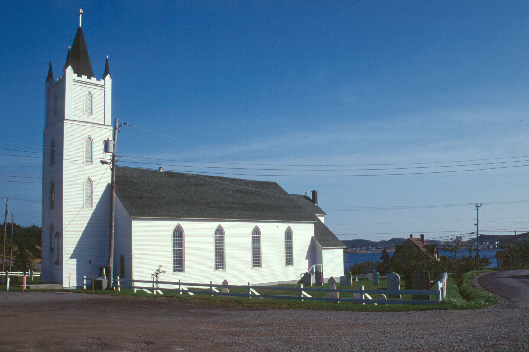
The town of Twillingate developed as a fishing centre in the mid 1700s and became very prosperous. Historic St. Peter’s Anglican Church, started in 1839, is a ‘must see’, in fact it would be very difficult to miss this grand edifice with its great white steeple towering over the town. At its side is a small cemetery. Pull into the parking lot, and go inside to see the beautiful interior. Next door to it, in the old Anglican Rectory, is the Twillingate Museum.
Twillingate is the kind of town you’d expect to find Agatha Christie’s characters heading off to for a quiet holiday. It’s the kind of town where you stop at a ‘Bed and Breakfast’ for the night, and end up staying for the week. Everywhere we travelled, we saw attractive “Bed and Breakfast” homes, and comfortable-looking small inns. In Twillingate, the Fish, Fun, and Folk festival in July draws large crowds of people who want to enjoy great music, and stage shows. There are also lots of crafts, and tempting home baking.
Many individuals catch a few fish to help them over the winter, when garden vegetables are scarcer. It’s very common to see the freshly caught fish drying on racks beside their house. We stopped to visit with a gentleman who explained the drying and salting process to us. Two of his sons have stayed on the island, and are fishermen. As is the unfortunate case with many families, two others have moved away to other parts of Canada to take jobs. His home has a delightful view from a vantage point on a hill down across the harbour.
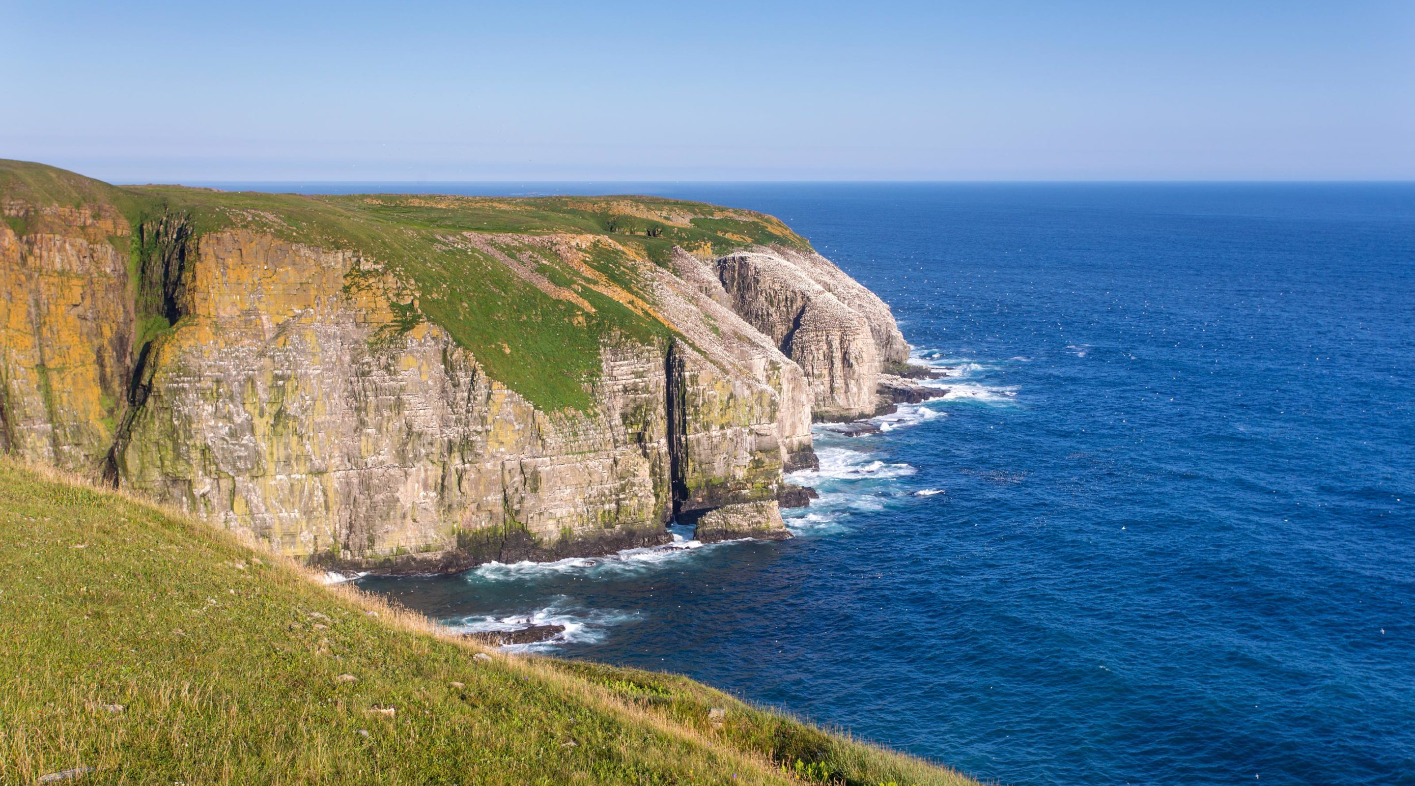
A short distance north of Twillingate is the Long Point Lighthouse, built in 1876, and perched almost 300 feet above the Atlantic. Drivers should be aware that the road to the lighthouse is very steep. The view from the top is great! The massive cliff is partially undercut, giving you the feeling you are hanging a few hundred feet over the water. Below, large waves shatter against the rocks, leaving spray and white water in the aftermath. Eastward, the blue ocean pinches out at the horizon, a placid painting of blue with white flecks, today, looking absolutely harmless, and beautiful. But it’s not always that way, as evidenced by the high wave swept rocks of the shoreline. Be careful, and watch your footing. Fog and dampness may make the grass and rock slippery.
This is a great viewing point for the massive icebergs that float south through Iceberg Alley. Calved from glaciers in fjords far to the north along the coast of Greenland, these behemoth, floating masses of ice can be strikingly attractive. Many icebergs are bigger than large office buildings, and may be up to 15,000 years old. Does the iceberg look big? Remember that almost 90% of the iceberg is submerged. There are many iceberg grooves across the Grand Banks where the iceberg has ploughed and dragged its way across the shallower water of the underwater plateau. Boat tours offer the opportunity to view icebergs up closer, but icebergs can be dangerous. Sides may calve from the main iceberg with thunderous results, and tumultuous water. Sometimes an iceberg will roll over completely, with little, or no advance warning. Once in a while a wandering iceberg will get stuck in shallow water near land where it must stay until it breaks up, or melts enough to float free of the bottom. We missed seeing the icebergs as they usually pass through Iceberg Alley in Spring and early Summer.
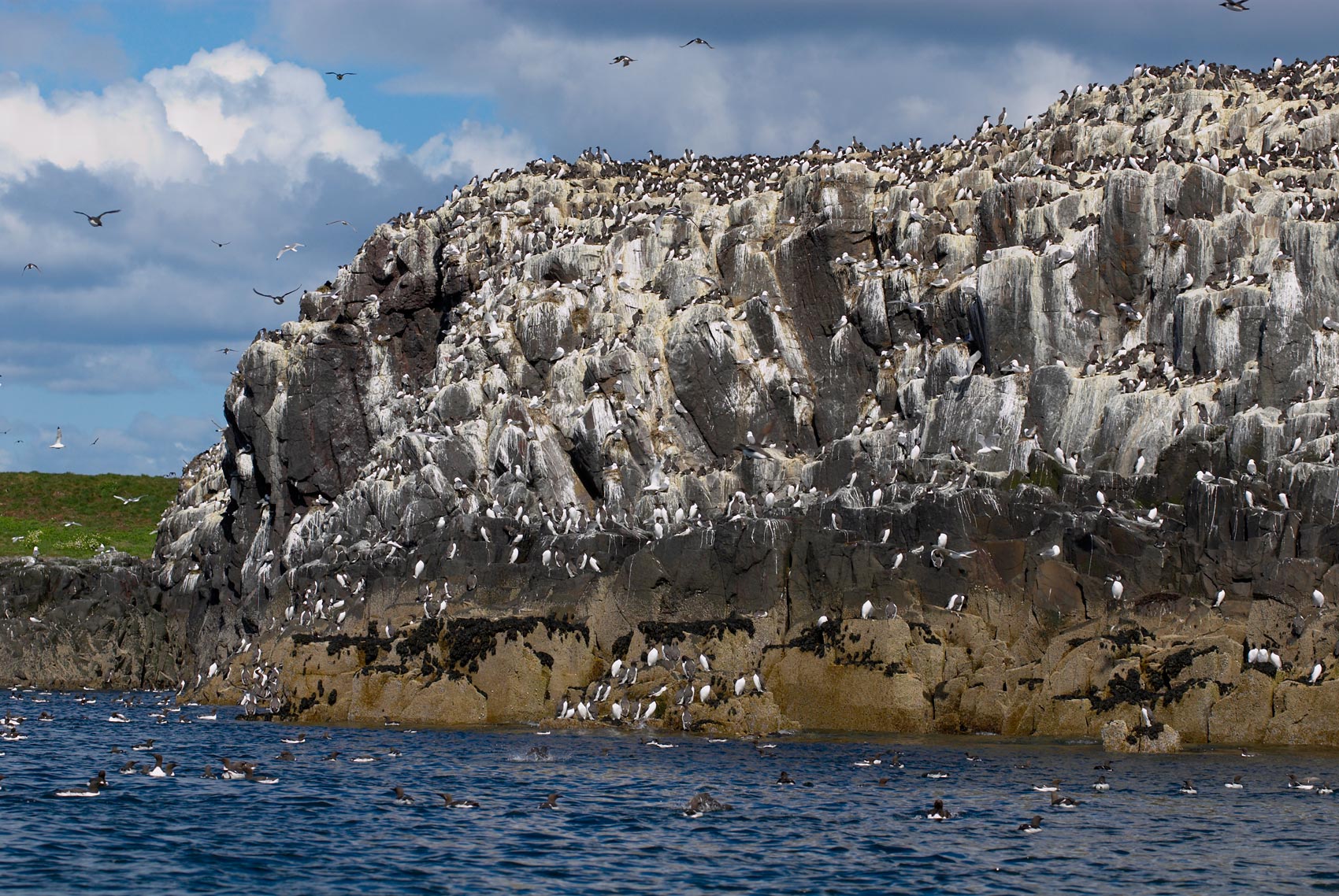
Whales are often seen from the lighthouse viewpoint too. The giant, humpback whale is a frequent visitor to Notre Dame Bay, and many tours take tourists on a whale-viewing trip. To watch the great whale breaching would be a magnificent sight. That’s quite a feat for a creature that may weigh more than a couple dozen tons. On this same tour you may frequently observe dolphin, porpoises, seals and many varieties of whales. Of course many of these are regularly observed from shore, along with lots of seabirds. Binoculars and cameras are the order of the day.
There are other Discovery roads on the Kittiwake Coast. The Road to the Beaches’, Route 310, and ‘Road to the Shore’, Routes 320, and 330, will both take you to many more exciting places. Budding geologists, for instance, will perhaps be excited to stand upon the Dover Fault, where the continents collided about 400,000 years ago.
Wherever you go, you can be comfortable with the thought that Newfoundland does not usually experience severe weather such as tornadoes and hurricanes. There are few earthquakes and no volcanoes. They don’t have poison ivy. No skunks. No porcupines. No snakes!
Newfoundland does have such a wide variety of scenery, and a population of folks that are easy to visit, and who are willing to help. You’ll be glad you went.
Comments